Project Summary
Thomas Cavanagh Construction Limited (Cavanagh Construction) has submitted an application for a “Class A”, below water pit license under the Aggregate Resources Act in the Geographic Township of Dalhousie, Township of Lanark Highlands, County of Lanark, Ontario. The applied for License would permit the operation of a pit for the extraction and processing of sand and gravel material from below the water table. The proposed pit is identified as the Highland Line Pit and is located on the south side of Highland Line, approximately 2.5 km south of the community of McDonalds Corners. The lands are legally described as Part of Lot 5, Concession 10, Geographic Township of Dalhousie, Township of Lanark Highlands, County of Lanark. The proposed Highland Line Pit will have a licensed area of approximately 50.6 hectares with the proposed area of operation (extraction area) being 35.1 hectares.
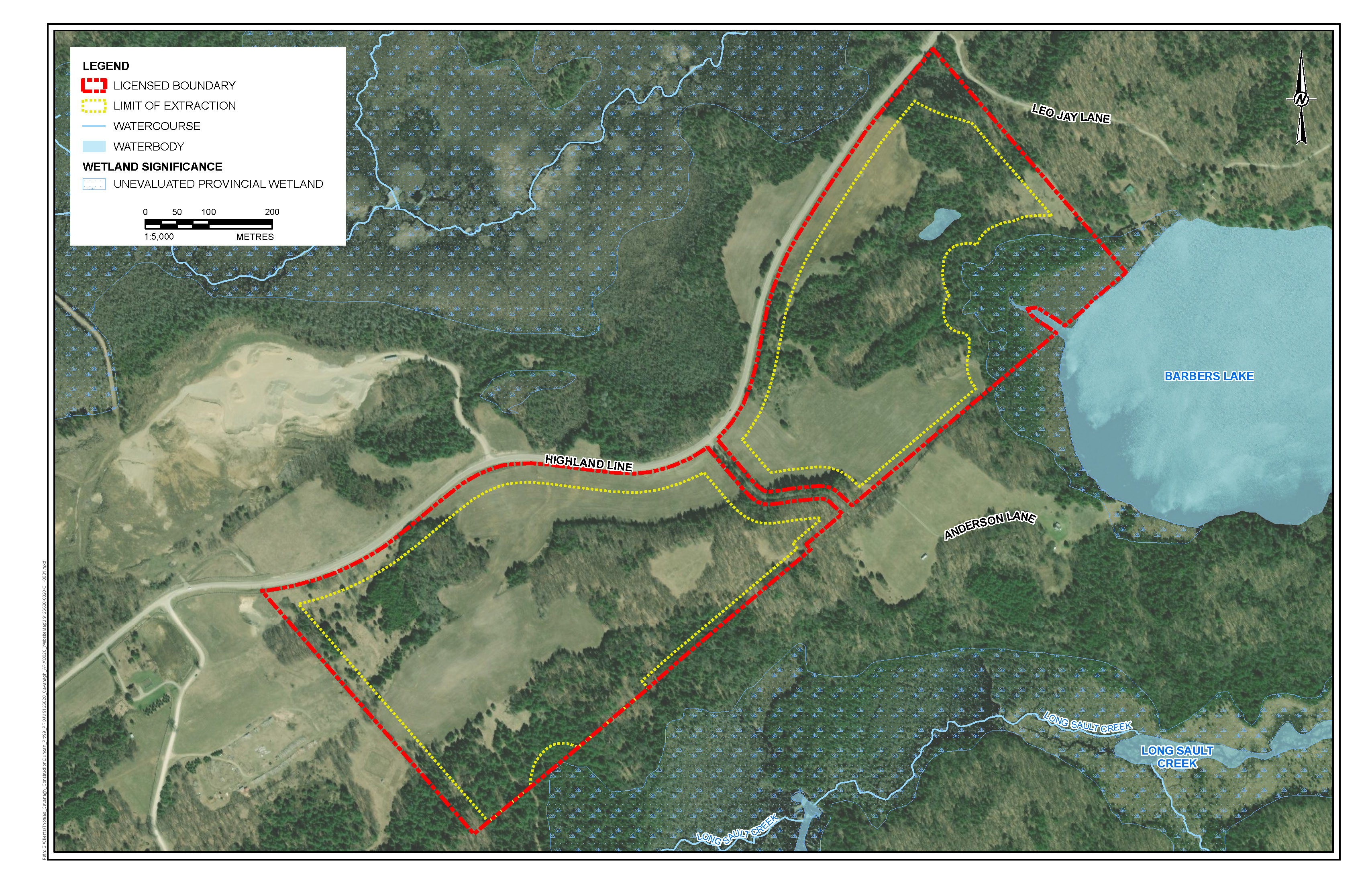
The site is comprised of two parcels separated by Anderson Lane. The two parcels are similar in size and shape. Both parcels comprising the site have frontage on Highland Line. The figure below shows the Highland Line Pit location and the approximate licensed boundary.
The eastern corner of the site is located adjacent to Barbers Lake. Further, Long Sault Creek, a cold-water feature, is located south of the site. At their closest point, Barbers Lake and Long Sault Creek are located more than 110 metres and 185 metres from the proposed extraction area, respectively. A 30-metre minimum setback is also being applied next to all wetlands.
Based on the proposed extraction area and the depth of extraction, there are at least 2 million tonnes of high-quality sand and gravel resources within the proposed Highland Line Pit. A large portion of the subject geological deposit is mapped by the Province as being a Sand and Gravel Resource Area of 'Primary Significance' in the County. The maximum annual tonnage is proposed to be 1,000,000 tonnes.
Sand and gravel extraction would occur above and below the water table using excavators and loaders. Excavated material would be transported to a screening plant located near the face of the pit. Processed aggregate would then be stockpiled and loaded onto highway trucks to deliver the product off-site. As this is a sand and gravel operation, there is no dewatering or blasting required to access the materials.
Based on the Traffic Impact Study, it is estimated that under worst case conditions 30 trucks will leave the site on an hourly basis. This is an absolute worst-case maximum traffic scenario which is permitted by the noise study. It is more likely that the traffic generated from this pit will be significantly lower.
As assessed in the Acoustic Assessment (Noise Study), the proposed pit is seeking permission to operate on a 24-hour basis. However, aggregate processing including any screening, washing or crushing would not be permitted between the hours of 7 pm to 7 am. Typically speaking the majority of pit operations including trucking would occur during the day. However, certain infrastructure projects require overnight work such as highway paving jobs. The ability to deliver asphalt and concrete stone, for example, during these periods is sometimes required.
Rehabilitation of the site will occur on a progressive basis and involves returning the site to natural features in the form of two lakes with shallow littoral zones located in areas having shallower slopes.
To permit the proposed pit, applications are required to amend the Lanark County Sustainable Communities Official Plan, and Township of Lanark Highlands Official Plan and Zoning By-law. Several nearby properties are currently zoned and designated for aggregate extraction and related uses. Portions of the site is recognized as containing significant aggregate resources based on both the Township’s Official Plan and Zoning By-law.
The technical studies and plans that accompany the application include, a Planning Justification & Aggregate Resources Act Summary Statement Report, an Aggregate Resources Act Site Plan, a Maximum Predicted Water Table Assessment, Level 1 and Level 2 Natural Environment Studies, Level 1 and Level 2 Water Assessments, Stage 1 through Stage 4 Archaeological Assessments, a Traffic Impact Study and a Noise Impact Assessment.
The aggregate licence application including all of the submitted technical studies have been circulated to several review agencies for review and comment including Ministry of Natural Resources and Forestry, County of Lanark, Township of Lanark Highlands, Mississippi Valley Conservation Authority, Ministry of Environment, Conservation and Parks, Fisheries and Oceans Canada, and Hydro One. Some of the technical studies including the Water Resources and Natural Environment Reports will be peer reviewed by experts on behalf of the Township and County.
These review agencies and expert peer reviewers will thoroughly review the technical studies and assess the proposed pit relative to compliance with applicable provincial regulations and municipal policies.
Public Notice of Application under Aggregate Resources Act
 Highland Line Pit - Public Notice of Application Form
The following provides a summary of each study that was completed and a link for you to be able to view the associated reports, if of interest.
Planning Justification & Aggregate Resources Act Summary Statement Report
A Planning Justification Report (MHBC, December, 2022) was prepared to review and assess the proposed pit relative to provincial, Lanark County (the County) and Township of Lanark Highlands (the Township) land use planning policies and regulations. The Planning Justification Report also includes a Summary Statement as required by the Aggregate Resources Act which outlines planning and land use considerations, agricultural classification of the site, any Source Protection Area considerations, the quality and quantity of aggregate resources, projected truck traffic, and the proposed progressive and final rehabilitation plans.
The site is designated Rural in the County’s Official Plan and Rural Communities in the Township’s Official Plan. The site is zoned Mineral Aggregate Resources Reserve and Rural in the Township’s Zoning By-law. To permit extraction on the site, applications to amend the County’s Official Plan, and the Township’s Official Plan and Zoning By-law have been submitted.
Site Plan
As required by the Aggregate Resources Act, a site plan has been prepared which identifies the existing features on and adjacent to the site, the operational requirements and conditions for the pit, and how the site will be progressively rehabilitated following aggregate extraction.
Maximum Predicted Groundwater Table Assessment
The Maximum Predicted Groundwater Table Assessment (WSP Golder, December 12, 2022) for the proposed Highland Line Pit was conducted using subsurface investigation methods to establish the elevation of the groundwater table at the site. Based on the available groundwater elevation data, the maximum predicted water table on the site is 195.4 metres above sea level on the southern corner. Based on the groundwater elevation data measured at monitoring wells installed across the site, the water table slopes down moving from southwest to east, and the maximum predicted water table on the east side of the site (near Barbers Lake) is approximately 182.9 metres above sea level.
Level 1 and Level 2 Water Report
The Level 1 and Level 2 Water Report (WSP Golder, December 2022) was completed to support an application under the Aggregate Resources Act, and to ensure that the hydrogeological considerations of the Province, County and Township had been met.
Two field investigations were carried out at the site in 2019 and 2020 and included the excavation of 22 test pits and the installation of six monitoring wells that were completed in the overburden deposits. Water levels were measured on a monthly basis from April 2020 to June 2021 and continue to be monitored.
To assess the surface water levels at three surface water locations, staff gauges were installed in the wetland along the northern site boundary, just south of the crossing of Highland Line and Leo Jay Lane, and near the marshes along the eastern site boundary, adjacent to Barbers Lake. A wellpoint was also installed adjacent to Barbers Lake. Data loggers were installed at each location and programmed to record water levels at 15-minute intervals.
The operations in the pit will include the removal of overburden materials to an approximate pit base elevation of 176 metres above sea level. Material extraction will not require dewatering. Given that the aggregate extraction below the groundwater table will occur without dewatering, there will be no significant lowering of the groundwater table in the overburden and underlying bedrock and thus no potential for proposed extraction activities to cause drawdown of the groundwater table such that it interferes with local water supply wells.
Operation of the proposed pit area is not expected to contribute to flooding problems in the receiving drainage features, as there will be limited water discharge from the pit. The pit itself is expected to operate as a large infiltration basin. The redirection of catchment areas from the north, from the east, and from the southeast to the pit area thus results in an overall reduction in peak surface flow rates in all directions.
Overall, the surface water impacts associated with the proposed pit are marginal. Changes in contributing catchment to the assessed surface water bodies (Long Sault Creek, Barbers Lake and the unnamed northern wetland) are on the order of 2%, while infiltration is still estimated to report to two out of the three adjacent waterbodies as baseflow.
Based on the findings of this assessment, no adverse effects to groundwater and surface water resources and their uses are anticipated as a result of the proposed Highland Line Pit.
Level 1 and Level 2 Natural Environment Studies
The Level 1 and Level 2 Natural Environment Studies (WSP Golder, December 2022) were completed to support an application under the Aggregate Resources Act, and to ensure that the natural environment considerations of the Province, County and Township had been met.
To develop an understanding of the drainage patterns, ecological communities and potential natural heritage features that may be affected by the proposed aggregate extraction, both desktop and field assessments were conducted.
The assessment involved the investigation of existing conditions on-site and within the study area. It included a background information search and literature review to gather data about the local area and provide context for the evaluation of the natural features. Additionally, A Species at Risk (SAR) screening was completed on-site and for the study area, focusing on the review of records and range maps pertaining to species that are designated as threatened, endangered or special concern under the Endangered Species Act (ESA), and species that are protected under Schedule 1 of the Species at Risk Act (SARA).
The habitats and wildlife and plant communities on the site and in the study area were characterized through field surveys including: anuran (i.e., frogs), turtle, visual encounter, bat, plant community and breeding bird surveys. During all surveys, area searches were conducted, and wildlife, plant, and habitat observations were recorded. Searches were also conducted to document the presence or absence of suitable habitat, based on habitat preferences, for those species identified in the desktop SAR screening.
Overall, through the impact analysis conducted for the proposed extraction, it was determined that no negative impacts are expected to the significant natural features in the study area. In addition, a rehabilitation plan and ecologically based mitigation measures have been developed and are included in the Aggregate Resources Act site plan.
Stage 1 Through Stage 4 Archaeological Assessments
Archaeological assessments are required by the planning policies of the Province, County, and Township to ensure that the proposed development conserves significant archaeological resources.
Stage 1 and 2 Archaeological Assessments were conducted for the proposed subject lands in (April of 2021) by Golder Associates as required under the Aggregate Resources Act and Planning Act application processes.
The Stage 2 Archaeological Assessment recommended further assessment of two identified archaeological sites; Turnbull and Duncan, which have been interpreted as 19th century farmsteads. Within these sites, the archaeological assessment had found approximately 20 mid-19th century artifacts including a large amount of mid-19th century ceramic tableware.
Additionally, the archaeological assessments stated that the Duncan and Turnbull sites possess Cultural Heritage Value/Interest and were subject to Stage 3 and 4 archaeological assessments. The Stage 3 and 4 assessments for the two sites were completed, and the archeological resources have been conserved as confirmed by the Ministry of Tourism, Culture and Sport.
Areas with remaining archaeological work have been identified on the ARA site plans. Prior to any extraction or disturbance of these areas, additional archaeological assessment will be required in addition to appropriate clearances obtained from the Ministry of Tourism, Culture and Sport.
Archaeological Stage 1 and 2 Reports
Stage 3 Archaeological Assessments
Stage 4 Archaeological Assessments
Qualifications and Experience of the Report Authors
Letters were received from the Ministry of Heritage, Culture and Sport. The letters state that, after review of the various reports, the Ministry is satisfied that the fieldwork and reporting for the archaeological assessments are consistent with the 2011 Standards and Guidelines for Consultant Archaeologists and the terms and conditions for archaeological licences. The letters confirm that the reports will be entered into the Ontario Public Register of Archaeological Reports.
Acoustic Assessment Report
The Acoustic Assessment Report (Freefield Ltd., September 2022) assesses the potential impact of noise from the proposed Highland Line Pit operations on nearby receptors in accordance with Ministry of Environment, Conservation and Parks guidelines for noise assessments. The assessment considers the impact on nearby noise sensitive lands, including existing residences and vacant land zoned for potential noise sensitive uses, of noise generated by all on-site equipment operations, including extraction operations by loaders or excavators, aggregate processing operations by a crushing plant, screening plant and wash plant, loading operations by loaders, site preparation and maintenance by an excavator and truck movements used for the shipping of product off-site.
Thirteen nearby noise sensitive receptors consisting of private residences, hunting camps and businesses were identified for detailed noise evaluation. The evaluated receptors are the closest to the proposed pit in all directions, representing the worst-case noise impacts in comparison to other nearby or more distant noise sensitive receptors.
The most significant noise sources were identified as the mobile screening plant, wash plant, diesel generator, mobile crushing plant, excavators, front end loaders and on-site truck movements to ship the product off-site. In order to consider cases of worst-case noise impacts, nine operational scenarios were modeled and the six worst-case are presented in the report. In general, the worst impacts are those which occur when all equipment is operating concurrently.
The report concluded that predicted noise levels at nearby noise sensitive points of reception from the operations at the proposed Highland Line Pit will be in compliance with Ministry of Environment, Conservation and Parks sound level limits provided that specific noise control and mitigation measures are followed. The specific noise control and mitigation measures are included in the Acoustic Assessment Report and on the Aggregate Resources Act site plan.
Traffic Impact Study
The Traffic Impact Study was completed by Castleglenn Consultants in September 2022. The Traffic Impact Study included a study area consisting of Lanark County Road 12 and Highland Line, and the intersections of County Road 12/Highland Line-McCulloch Road and Highland Line/Existing Quarry Access to the north. The Traffic Impact Study included a review of existing background traffic within the study area (including the collection of traffic count information), a description of the proposed extraction site and its anticipated impact on future traffic operations, a site traffic forecast for future peak hour operations (2024), and a review of the proposed access arrangements.
Traffic counts were undertaken in December 2021. Recognizing the seasonal variation in traffic levels for this area, the traffic counts along Highland Line were increased by approximately 10 times.
The Study found that the worst-case traffic generated by the proposed pit is 30 two-way truck trips during both the morning and afternoon peak hours. The Study concluded that both intersections within the study area are forecast to continue to operate acceptably during the peak hours of travel demand during the forecast horizon year (2024).
Additional Material
The following provides links to the material that was presented at the Aggregate Resources Act Public Information Session held on April 27, 2023 for the proposed Highland Line Pit.
Location Map of the Proposed Highland Line Pit (Poster)
Site Plan (Poster)
Hydrogeological/Hydrological Figure (Poster)
Natural Environment Figure (Poster)
Public Presentation
A – Response to Public Comments (January 15, 2025)
B - Revised Site Plan (January 13, 2025)
C – Uranium and Thorium Investigation (October 29, 2024)
D - Planning Addendum Report (January 2025)
E – Stage 1-2 Archaeological Assessment (February 11, 2025)
F – Response to Comments from Mark Heaton, Ecologist (Friends of Lanark Highlands) (January 10, 2025)
G - Response to Natural Environment Peer Review Comments (Township of Lanark Highlands) (January 10, 2025)
H – Fisheries and Oceans Canada Project Review (March 12, 2024)
I - Well Interference Complaint Program
A – Traffic Impact Study Peer Response Letter (May 30, 2025)
B –Hydrogeological Assessment Peer Review (Friends of Lanark Highland) Response (June 13, 2025)
C – Natural Environment Report Peer Review Response (June 16, 2025)
D - Acoustic Assessment Report Peer Review Response - (September 5, 2025)
A – Updates to Cavanagh’s Highland Line Pit Application (September 9, 2025)
B – Revised Site Plan (September 8, 2025)
C – Visual Assessment for Barbers Lake (September 5, 2025)
D – Updated Acoustic Assessment Report (September 5, 2025)
A - Highland Line Pit Slope Stability Assessment (October 2, 2025)
B - Response to MNR comments (October 8, 2025)
C - Traffic Impact Study 2nd Peer Response Letter (October 9, 2025)